






Yonaguni Island—Tahara River Wetlands—
Ishigaki Island Tourist Information
◆Ishigaki Island for sightseeingRental car required.Oh my god!!!
Early reservations are recommended as they fill up quickly.
Early reservations are recommended as they fill up quickly.

◆Tuk-tuks and electric trikes are also popular!

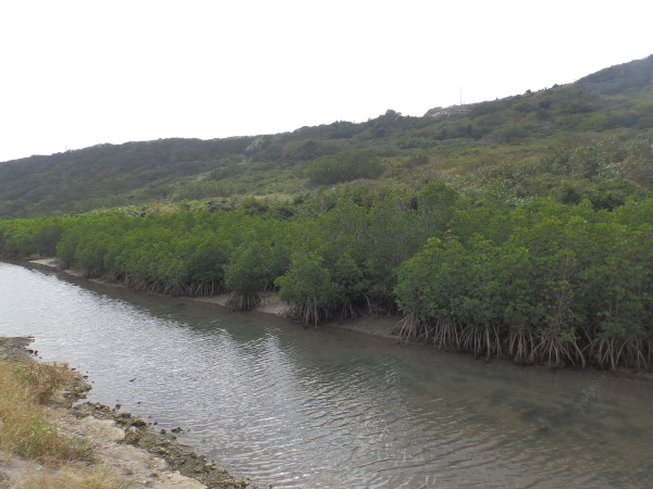
What Is the Tahara River Wetland?
The Tahara River is a small river that flows through the northern part of Yonaguni Island, originating at the foot of Mount Urabe and emptying into Sona Port. It flows near the island’s central area, including the town hall. The area extending about 600 meters from its mouth is a brackish water zone, forming a wetland where mangroves can be seen. Although these mangroves were actually planted, the sight of them spreading right next to the village is truly characteristic of Yonaguni Island!
Details on the Tahara River Wetlands
| Location | Yonaguni-cho, Yaeyama District, Okinawa Prefecture, Aza Yonaguni-Sonai (View in MAP) |
| Access | About a 5-minute drive from Yonaguni Airport |
| parking lot | nashi (Pyrus pyrifolia, esp. var. culta) |
| toilet | nashi (Pyrus pyrifolia, esp. var. culta) |
| Business Hours | - |
See all activities Ishigaki Island Tours ← Back to the List of Basic Information and Recommended Spots on Yonaguni Island



























































![[Ishigaki Island / Approx. 2.5 hours] Same-day reservations accepted! SUP tour to the mystical “Blue Cave”★ A new experience in crystal-clear waters♪ Free photos](https://ishigaki-tours.com/wp-content/uploads/2017/12/DB89F99F-C338-4E76-BC19-CEC4FDDE95AC-1-825x510.jpeg)